Author: U.S Army, Corps of Engineers
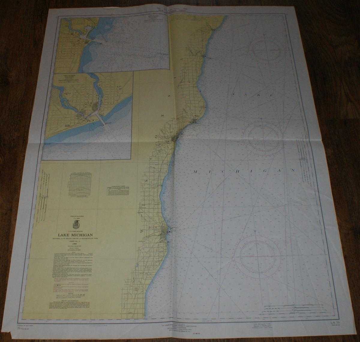
Title: Nautical Chart Lake Michigan No. L.S.73 Algoma to 18 miles south of Sheboygan, Wisconsin, Scale 1:20,000
Description: U.S. Army Engineer District Corps of Engineers, 1966. Revised Edition, Softcover. Good Condition/No Dust Jacket. Colour chart with both vertical and horizontal centre folds. Sheet is slightly creased, particularly down the right hand side. Edges are a little worn and a small piece has been torn from the bottom left corner margin. Nautical Chart Lake Michigan No. L.S.73 Algoma to 18 miles south of Sheboygan, Wisconsin. U.S. Lake Survey 125th Anniversary Edition. Edition of July 1966 with corrections to March 1969. Scale 1:20,000 Area Covered: Lake Michigan (part), Wisconsin (part), Onion River, Black River, Sheboygan, Manitowoc, Two Rivers, Kewaunee, Algoma, Sheet contains two inset plans: Kewaunee at scale 1:10,000 Two Rivers at scale 1:10,000 Reverse shows U.S Lake Survey's Outline of Charts of the Great Lakes Size: 123x91cm. No dust jacket, as published. Single sheet map/chart. Quantity Available: 1. Shipped Weight: under 1 kg. Pictures of this item not already displayed here available upon request. Inventory No: 45517034044. ISBN: 090019720X
Keywords: BZDB4 , nautical chart, shipping Maps; USA & Canada; naval, naval history, maritime, ships, boats. U.S Army, Corps of Engineers Nautical Chart Lake Michigan No. L.S.73 Algoma to 18 miles south of Sheboygan, Wisconsin, Scale 1:20,000 USA & Canada naval,
See more books from our catalog: Maps
Title: Nautical Chart Lake Michigan No. L.S.73 Algoma to 18 miles south of Sheboygan, Wisconsin, Scale 1:20,000
Description: U.S. Army Engineer District Corps of Engineers, 1966. Revised Edition, Softcover. Good Condition/No Dust Jacket. Colour chart with both vertical and horizontal centre folds. Sheet is slightly creased, particularly down the right hand side. Edges are a little worn and a small piece has been torn from the bottom left corner margin. Nautical Chart Lake Michigan No. L.S.73 Algoma to 18 miles south of Sheboygan, Wisconsin. U.S. Lake Survey 125th Anniversary Edition. Edition of July 1966 with corrections to March 1969. Scale 1:20,000 Area Covered: Lake Michigan (part), Wisconsin (part), Onion River, Black River, Sheboygan, Manitowoc, Two Rivers, Kewaunee, Algoma, Sheet contains two inset plans: Kewaunee at scale 1:10,000 Two Rivers at scale 1:10,000 Reverse shows U.S Lake Survey's Outline of Charts of the Great Lakes Size: 123x91cm. No dust jacket, as published. Single sheet map/chart. Quantity Available: 1. Shipped Weight: under 1 kg. Pictures of this item not already displayed here available upon request. Inventory No: 45517034044. ISBN: 090019720X
Keywords: BZDB4 , nautical chart, shipping Maps; USA & Canada; naval, naval history, maritime, ships, boats. U.S Army, Corps of Engineers Nautical Chart Lake Michigan No. L.S.73 Algoma to 18 miles south of Sheboygan, Wisconsin, Scale 1:20,000 USA & Canada naval,
Price: GBP 24.00 = appr. US$ 34.27 Seller: Bailgate Books Ltd
- Book number: 45517034044
- Book number: 45517034044
See more books from our catalog: Maps