Author: Admiralty
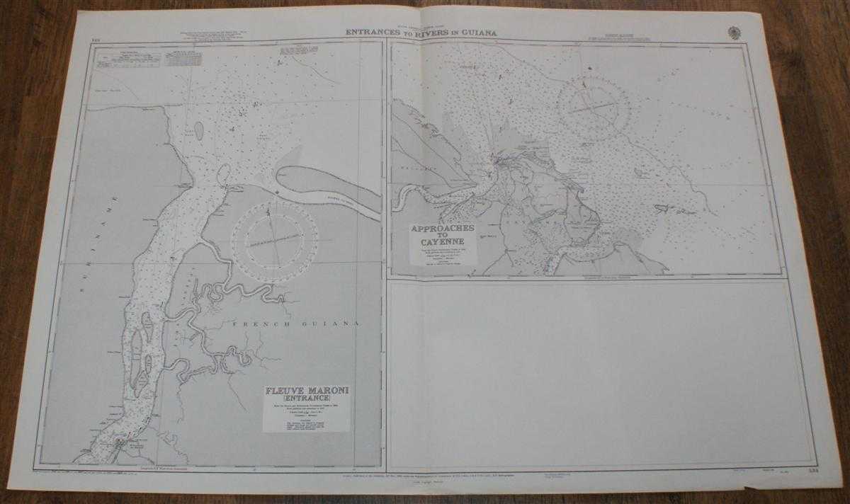
Title: Nautical Chart No. 534. South America North Coast, Entrances to Rivers in Guiana. Fleuve Maroni (Entrance) From the French and Netherlands Government Charts to 1965. Approaches to Cayenne, from the French Government Chart of 1956, Scale 1:75,000
Description: Map Admiralty, London, 1970. Revised Edition, Softcover. Very Good Condition/No Dust Jacket. Crisp clean black and white chart. Single vertical fold. Nautical Chart No. 534. South America North Coast, Entrances to Rivers in Guiana. Fleuve Maroni (Entrance) From the French and Netherlands Government Charts to 1965. Additions and Corrections to 1957, Small corrections to 1970, Scale 1:75,000. Approaches to Cayenne, from the French Government Chart of 1956, Additions and Corrections to 1957, Small corrections to 1970, Scale 1:75,000. Area covered: Suriname, French Guiana; Rivere La Mana, Tijger Bank, Iles Remire, Cayenne, Ilesaussat, St. Laurent du Maroni. Size: 1040mm x 710mm. Item Type: Map. No dust jacket, as published. Single sheet map/chart which is suitable for framing and will be shipped rolled and in a cardboard tube.. Quantity Available: 1. Shipped Weight: under 1 kg. Pictures of this item not already displayed here available upon request. Inventory No: 45516041175. ISBN: 019820227X
Keywords: BZDB4 , nautical chart, shipping, Maps; South & Central America & the West Indies; naval, naval history, maritime, ships, boats. Admiralty Nautical Chart No. 534. South America North Coast, Entrances to Rivers in Guiana. Fleuve Maroni (Entrance) From the
See more books from our catalog: Maps
Title: Nautical Chart No. 534. South America North Coast, Entrances to Rivers in Guiana. Fleuve Maroni (Entrance) From the French and Netherlands Government Charts to 1965. Approaches to Cayenne, from the French Government Chart of 1956, Scale 1:75,000
Description: Map Admiralty, London, 1970. Revised Edition, Softcover. Very Good Condition/No Dust Jacket. Crisp clean black and white chart. Single vertical fold. Nautical Chart No. 534. South America North Coast, Entrances to Rivers in Guiana. Fleuve Maroni (Entrance) From the French and Netherlands Government Charts to 1965. Additions and Corrections to 1957, Small corrections to 1970, Scale 1:75,000. Approaches to Cayenne, from the French Government Chart of 1956, Additions and Corrections to 1957, Small corrections to 1970, Scale 1:75,000. Area covered: Suriname, French Guiana; Rivere La Mana, Tijger Bank, Iles Remire, Cayenne, Ilesaussat, St. Laurent du Maroni. Size: 1040mm x 710mm. Item Type: Map. No dust jacket, as published. Single sheet map/chart which is suitable for framing and will be shipped rolled and in a cardboard tube.. Quantity Available: 1. Shipped Weight: under 1 kg. Pictures of this item not already displayed here available upon request. Inventory No: 45516041175. ISBN: 019820227X
Keywords: BZDB4 , nautical chart, shipping, Maps; South & Central America & the West Indies; naval, naval history, maritime, ships, boats. Admiralty Nautical Chart No. 534. South America North Coast, Entrances to Rivers in Guiana. Fleuve Maroni (Entrance) From the
Price: GBP 24.00 = appr. US$ 34.27 Seller: Bailgate Books Ltd
- Book number: 45516041175
- Book number: 45516041175
See more books from our catalog: Maps