Author: Admiralty
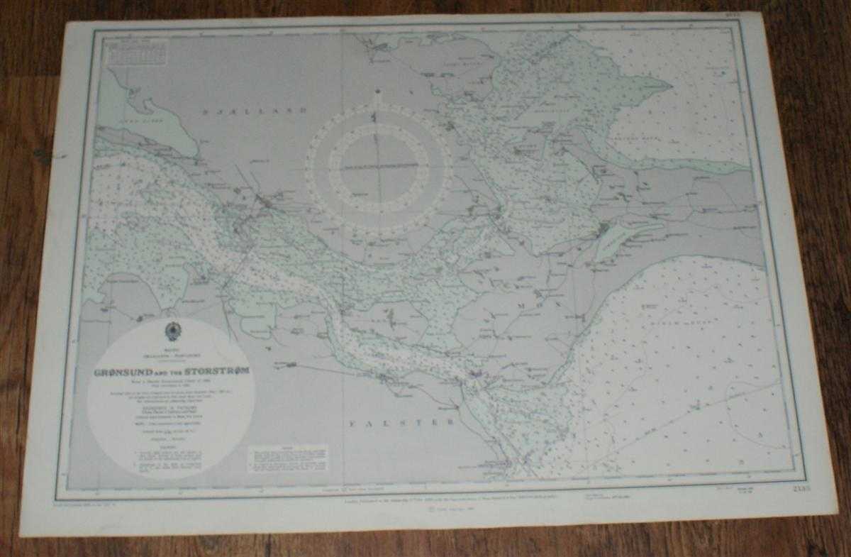
Title: Nautical Chart No. 2138. Smaalands - Farvandet: Gronsund and the Storstrom. From a Danish Government Chart of 1924 with corrections to 1965. Small corrections to 1973. Scale 1:75,000
Description: Map Admiralty, London, 1973. Revised Edition, Softcover. Very Good Condition/No Dust Jacket. Crisp clean coloured chart. Nautical Chart No. 2138. Smaalands - Farvandet: Gronsund and the Storstrom. From a Danish Government Chart of 1924 with corrections to 1965. Small corrections to 1973. Scale 1:75,000. Covers: Denmark, Falster, Hestehoved, Naesgaard, Stubbekobing, Gundslev, Farnaes, Vaalse, Mon, Borgsted, Hjelm, Raabymagle, Nordfeldt, Udby, Ulvshale, Stege, Lindemarke, Nyord, Jungs-Hoved, Praesto, Sandvig, Kallehave, Vordingborg, Rosenfeld, Sjaelland, Storstrom, Hjelm Bugt. Size: 520mm x 710mm. Item Type: Map. No dust jacket, as published. Single sheet map/chart which is suitable for framing and will be shipped rolled and in a cardboard tube.. Quantity Available: 1. Shipped Weight: under 1 kg. Pictures of this item not already displayed here available upon request. Inventory No: 45516011120. ISBN: 019281219X
Keywords: BZDB4 , nautical chart, shipping, Scandinavia, Sweden, Denmark, Baltic Maps; Scandinavia; naval, naval history, maritime, ships, boats. Admiralty Nautical Chart No. 2138. Smaalands - Farvandet: Gronsund and the Storstrom. From a Danish Government Chart of
See more books from our catalog: Maps
Title: Nautical Chart No. 2138. Smaalands - Farvandet: Gronsund and the Storstrom. From a Danish Government Chart of 1924 with corrections to 1965. Small corrections to 1973. Scale 1:75,000
Description: Map Admiralty, London, 1973. Revised Edition, Softcover. Very Good Condition/No Dust Jacket. Crisp clean coloured chart. Nautical Chart No. 2138. Smaalands - Farvandet: Gronsund and the Storstrom. From a Danish Government Chart of 1924 with corrections to 1965. Small corrections to 1973. Scale 1:75,000. Covers: Denmark, Falster, Hestehoved, Naesgaard, Stubbekobing, Gundslev, Farnaes, Vaalse, Mon, Borgsted, Hjelm, Raabymagle, Nordfeldt, Udby, Ulvshale, Stege, Lindemarke, Nyord, Jungs-Hoved, Praesto, Sandvig, Kallehave, Vordingborg, Rosenfeld, Sjaelland, Storstrom, Hjelm Bugt. Size: 520mm x 710mm. Item Type: Map. No dust jacket, as published. Single sheet map/chart which is suitable for framing and will be shipped rolled and in a cardboard tube.. Quantity Available: 1. Shipped Weight: under 1 kg. Pictures of this item not already displayed here available upon request. Inventory No: 45516011120. ISBN: 019281219X
Keywords: BZDB4 , nautical chart, shipping, Scandinavia, Sweden, Denmark, Baltic Maps; Scandinavia; naval, naval history, maritime, ships, boats. Admiralty Nautical Chart No. 2138. Smaalands - Farvandet: Gronsund and the Storstrom. From a Danish Government Chart of
Price: GBP 24.00 = appr. US$ 34.27 Seller: Bailgate Books Ltd
- Book number: 45516011120
- Book number: 45516011120
See more books from our catalog: Maps