Author: John Bartholomew & Son Ltd.
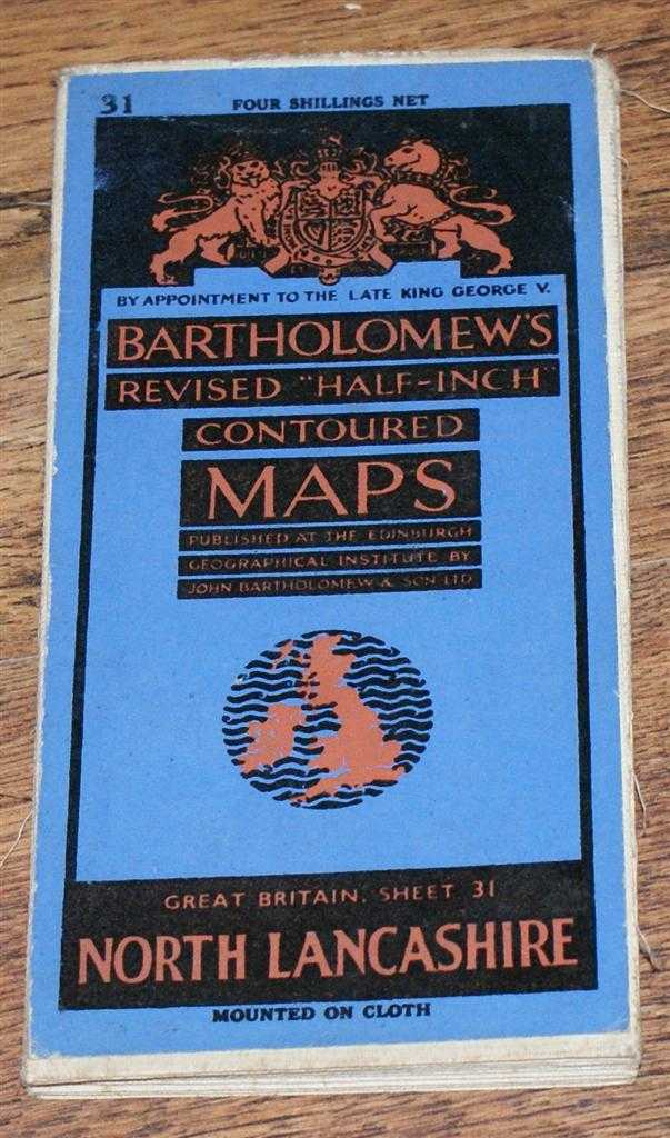
Title: North Lancashire and Isle of Man - Bartholomew's Revised "Half-Inch" Contoured Maps, Great Britain Sheet 31
Description: John Bartholomew & Son Ltd. Edinburgh, 1946. Revised Edition, Softcover. Very Good Condition/No Dust Jacket. Map is undated by publisher and the date given is estimated only. Single sheet map is cloth backed and has blue card covers. Sheet is folded as for original sale. Scale 1:126,720 or Half-Inch to Mile. Map is coloured according to contour and main roads are shown in red. Rivers, railways, canals, etc. are clearly indicated. A and B road numbers are given. County boundaries and Overhead Electrical Power Lines also shown. Covers are clean but worn. Sheet is slightly worn and darkened around the edges. The folds are a little rubbed and in some instances very slightly darkened. Area covered includes; Isle of Man, Ramsey, Douglas, Preston, Barrow, Blackburn, Burnley, Lancaster, Settle, Clitheroe, Darwen, Chorely, Rochdale (part), Southport, Blackpool, Fleetwood, Morecambe Bay. Size: 84x59cm. Single sheet map/chart which is suitable for framing. Quantity Available: 1. Shipped Weight: under 1 kg. Pictures of this item not already displayed here available upon request. Inventory No: 45119093029. ISBN: 0140063803
Keywords: BZDB4 Maps; Isle of Man; Lancashire. John Bartholomew & Son Ltd. North Lancashire and Isle of Man - Bartholomew's Revised "Half-Inch" Contoured Maps, Great Britain Sheet 31 Isle of Man Lancashire
See more books from our catalog: Maps
Title: North Lancashire and Isle of Man - Bartholomew's Revised "Half-Inch" Contoured Maps, Great Britain Sheet 31
Description: John Bartholomew & Son Ltd. Edinburgh, 1946. Revised Edition, Softcover. Very Good Condition/No Dust Jacket. Map is undated by publisher and the date given is estimated only. Single sheet map is cloth backed and has blue card covers. Sheet is folded as for original sale. Scale 1:126,720 or Half-Inch to Mile. Map is coloured according to contour and main roads are shown in red. Rivers, railways, canals, etc. are clearly indicated. A and B road numbers are given. County boundaries and Overhead Electrical Power Lines also shown. Covers are clean but worn. Sheet is slightly worn and darkened around the edges. The folds are a little rubbed and in some instances very slightly darkened. Area covered includes; Isle of Man, Ramsey, Douglas, Preston, Barrow, Blackburn, Burnley, Lancaster, Settle, Clitheroe, Darwen, Chorely, Rochdale (part), Southport, Blackpool, Fleetwood, Morecambe Bay. Size: 84x59cm. Single sheet map/chart which is suitable for framing. Quantity Available: 1. Shipped Weight: under 1 kg. Pictures of this item not already displayed here available upon request. Inventory No: 45119093029. ISBN: 0140063803
Keywords: BZDB4 Maps; Isle of Man; Lancashire. John Bartholomew & Son Ltd. North Lancashire and Isle of Man - Bartholomew's Revised "Half-Inch" Contoured Maps, Great Britain Sheet 31 Isle of Man Lancashire
Price: GBP 5.50 = appr. US$ 7.85 Seller: Bailgate Books Ltd
- Book number: 45119093029
- Book number: 45119093029
See more books from our catalog: Maps