Author: Alexander Keith Johnston
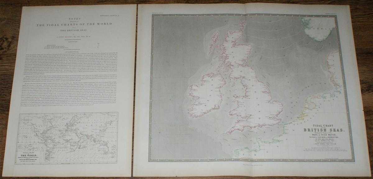
Title: Tidal Chart of the British Seas. Showing the Progress of the Wave of High Water, the Hour of High Water in Greenwich Time at New and Full Moon; and the Depth of the Sea
Description: Map William Blackwood & Sons, Edinburgh and London, 1848. First Edition, Softcover, Illustrated by: Engraved by W & A K Johnston. Very Good Condition/No Dust Jacket. Disbound map with single sheet with further map and accompanying notes from "The Physical Atlas, A Series of Maps & Notes Illustrating The Geographical Distribution of Natural Phenomena by Alexander Keith Johnston F.R.G.S. F.G.S. Geographer at Edinburgh in Ordinary to Her Majesty, Honorary Memeber of the Geographical Society Berlin, F.G.S Paris, Editor of the National Atlas &c. Based on the Physikalischer Atlas of Professor H. Berghaus et. al." Published in 1848 by William Blackwood & Sons of Edinburgh and London. Map sheet is entitled "Tidal Chart of the British Seas. Showing the Progress of the Wave of High Water, the Hour of High Water in Greenwich Time at New and Full Moon; and the Depth of the Sea" and has a vertical centre fold. Black and white engraving with grayscale shading and colour lines and wash to deliniate boarders. Faint transfer of image from facing page in some areas. Edges are slightly darkened and a little bumped with a small tear on the right and left hand margins. Lower margin of map reads "William Blackwood & Sons, Edinburgh & London". Accompanying sheet is entitled "Notes Explanatory of the Tidal Charts of the World and the British Isles. By J. Scott Russell" and contains a "Tidal Chart of the World" along with explanatory notes and tables. Size: 55x67cm. Item Type: Map. Single sheet map/chart which is suitable for framing. Illustrator: Engraved by W & A K Johnston. Quantity Available: 1. Shipped Weight: under 1 kg. Pictures of this item not already displayed here available upon request. Inventory No: 45117094090. ISBN: 0714820393
Keywords: BZDB4 Maps; British History; 18th & 19th century non-fiction; Geology, geography, mineralogy, environment. Engraved by W & A K Johnston Alexander Keith Johnston Tidal Chart of the British Seas. Showing the Progress of the Wave of High Water, the Hour of H
See more books from our catalog: Maps
Title: Tidal Chart of the British Seas. Showing the Progress of the Wave of High Water, the Hour of High Water in Greenwich Time at New and Full Moon; and the Depth of the Sea
Description: Map William Blackwood & Sons, Edinburgh and London, 1848. First Edition, Softcover, Illustrated by: Engraved by W & A K Johnston. Very Good Condition/No Dust Jacket. Disbound map with single sheet with further map and accompanying notes from "The Physical Atlas, A Series of Maps & Notes Illustrating The Geographical Distribution of Natural Phenomena by Alexander Keith Johnston F.R.G.S. F.G.S. Geographer at Edinburgh in Ordinary to Her Majesty, Honorary Memeber of the Geographical Society Berlin, F.G.S Paris, Editor of the National Atlas &c. Based on the Physikalischer Atlas of Professor H. Berghaus et. al." Published in 1848 by William Blackwood & Sons of Edinburgh and London. Map sheet is entitled "Tidal Chart of the British Seas. Showing the Progress of the Wave of High Water, the Hour of High Water in Greenwich Time at New and Full Moon; and the Depth of the Sea" and has a vertical centre fold. Black and white engraving with grayscale shading and colour lines and wash to deliniate boarders. Faint transfer of image from facing page in some areas. Edges are slightly darkened and a little bumped with a small tear on the right and left hand margins. Lower margin of map reads "William Blackwood & Sons, Edinburgh & London". Accompanying sheet is entitled "Notes Explanatory of the Tidal Charts of the World and the British Isles. By J. Scott Russell" and contains a "Tidal Chart of the World" along with explanatory notes and tables. Size: 55x67cm. Item Type: Map. Single sheet map/chart which is suitable for framing. Illustrator: Engraved by W & A K Johnston. Quantity Available: 1. Shipped Weight: under 1 kg. Pictures of this item not already displayed here available upon request. Inventory No: 45117094090. ISBN: 0714820393
Keywords: BZDB4 Maps; British History; 18th & 19th century non-fiction; Geology, geography, mineralogy, environment. Engraved by W & A K Johnston Alexander Keith Johnston Tidal Chart of the British Seas. Showing the Progress of the Wave of High Water, the Hour of H
Price: GBP 34.00 = appr. US$ 48.55 Seller: Bailgate Books Ltd
- Book number: 45117094090
- Book number: 45117094090
See more books from our catalog: Maps