Author: Ordnance Survey
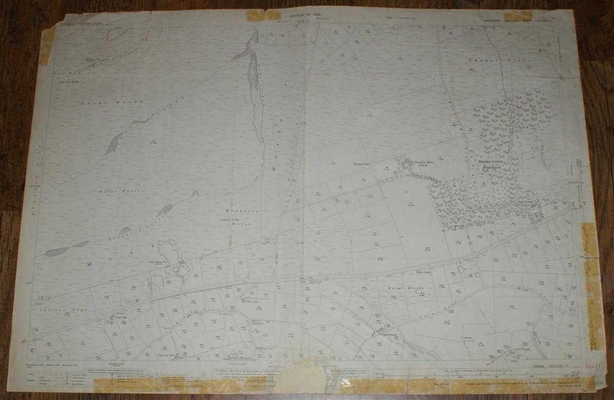
Title: 1:2,500 Ordnance Survey Map, Yorkshire (West Riding) Sheet CCLXXII.1. Edition of 1931, Re-Surveyed 1888, Revised 1929, Re-Levelled 1930, 75/31, Area Between Meltham and Holme
Description: Map Ordnance Survey, 1931. Revised Edition, Softcover. Fair Condition/No Dust Jacket. Black and white map. Map is lightly marked and smudged and has light pencil annotation. Slightly worn vertical centre fold with other creases with associated wear. Edges are slightly darkened and also have tape stains in various margins. Edges are otherwise torn and damaged with various tears but body of map is only encroached at bottom of centre fold where a small portion of the sheet has been torn off and an associated tear extends beyond the margin. Repair work has been attempted here. Top left corner of the margin has been torn off. Handwritten annotations in bottom right margin. Reverse is marked and rubbed with tape marks around edges. 1:2,500 Ordnance Survey Map, Yorkshire (West Riding) Sheet CCLXXII.1. Edition of 1931, Re-Surveyed 1888, Revised 1929, Re-Levelled 1930, 75/31, Area Between Meltham and Holme Knowl Height, Shay Clough, Turton's Edge, Kaye Stone Pits, Harden Moss Farm, Wood Cottage, Harden Green Plantation, Old Race Course (part), Magdalen Magdalen Road, Acres Lane, (A635), Harden Moss Road, Swimsey Dike, Rams Clough, Harden Clough, Information included is buildings, property/field boundaries, acreage, parish and other boundaries, footpaths, tracks, roads, railways, watercourses, orchards and forestation, levels, earthworks, antiquities, etc Size: 73cm by 104cm. Item Type: Map. No dust jacket, as published. Single sheet map/chart which is suitable for framing and will be shipped rolled and in a cardboard tube.. Quantity Available: 1. Shipped Weight: under 1 kg. Pictures of this item not already displayed here available upon request. Inventory No: 45116121350. ISBN: 0750920963
Keywords: BZDB4 map, British history Maps; British History; England; 1930s; Yorkshire. Ordnance Survey 1:2,500 Ordnance Survey Map, Yorkshire (West Riding) Sheet CCLXXII.1. Edition of 1931, Re-Surveyed 1888, Revised 1929, Re-Levelled 1930, 75/31, Area Between Melth
See more books from our catalog: Maps
Title: 1:2,500 Ordnance Survey Map, Yorkshire (West Riding) Sheet CCLXXII.1. Edition of 1931, Re-Surveyed 1888, Revised 1929, Re-Levelled 1930, 75/31, Area Between Meltham and Holme
Description: Map Ordnance Survey, 1931. Revised Edition, Softcover. Fair Condition/No Dust Jacket. Black and white map. Map is lightly marked and smudged and has light pencil annotation. Slightly worn vertical centre fold with other creases with associated wear. Edges are slightly darkened and also have tape stains in various margins. Edges are otherwise torn and damaged with various tears but body of map is only encroached at bottom of centre fold where a small portion of the sheet has been torn off and an associated tear extends beyond the margin. Repair work has been attempted here. Top left corner of the margin has been torn off. Handwritten annotations in bottom right margin. Reverse is marked and rubbed with tape marks around edges. 1:2,500 Ordnance Survey Map, Yorkshire (West Riding) Sheet CCLXXII.1. Edition of 1931, Re-Surveyed 1888, Revised 1929, Re-Levelled 1930, 75/31, Area Between Meltham and Holme Knowl Height, Shay Clough, Turton's Edge, Kaye Stone Pits, Harden Moss Farm, Wood Cottage, Harden Green Plantation, Old Race Course (part), Magdalen Magdalen Road, Acres Lane, (A635), Harden Moss Road, Swimsey Dike, Rams Clough, Harden Clough, Information included is buildings, property/field boundaries, acreage, parish and other boundaries, footpaths, tracks, roads, railways, watercourses, orchards and forestation, levels, earthworks, antiquities, etc Size: 73cm by 104cm. Item Type: Map. No dust jacket, as published. Single sheet map/chart which is suitable for framing and will be shipped rolled and in a cardboard tube.. Quantity Available: 1. Shipped Weight: under 1 kg. Pictures of this item not already displayed here available upon request. Inventory No: 45116121350. ISBN: 0750920963
Keywords: BZDB4 map, British history Maps; British History; England; 1930s; Yorkshire. Ordnance Survey 1:2,500 Ordnance Survey Map, Yorkshire (West Riding) Sheet CCLXXII.1. Edition of 1931, Re-Surveyed 1888, Revised 1929, Re-Levelled 1930, 75/31, Area Between Melth
Price: GBP 12.00 = appr. US$ 17.14 Seller: Bailgate Books Ltd
- Book number: 45116121350
- Book number: 45116121350
See more books from our catalog: Maps