Author: Ordnance Survey
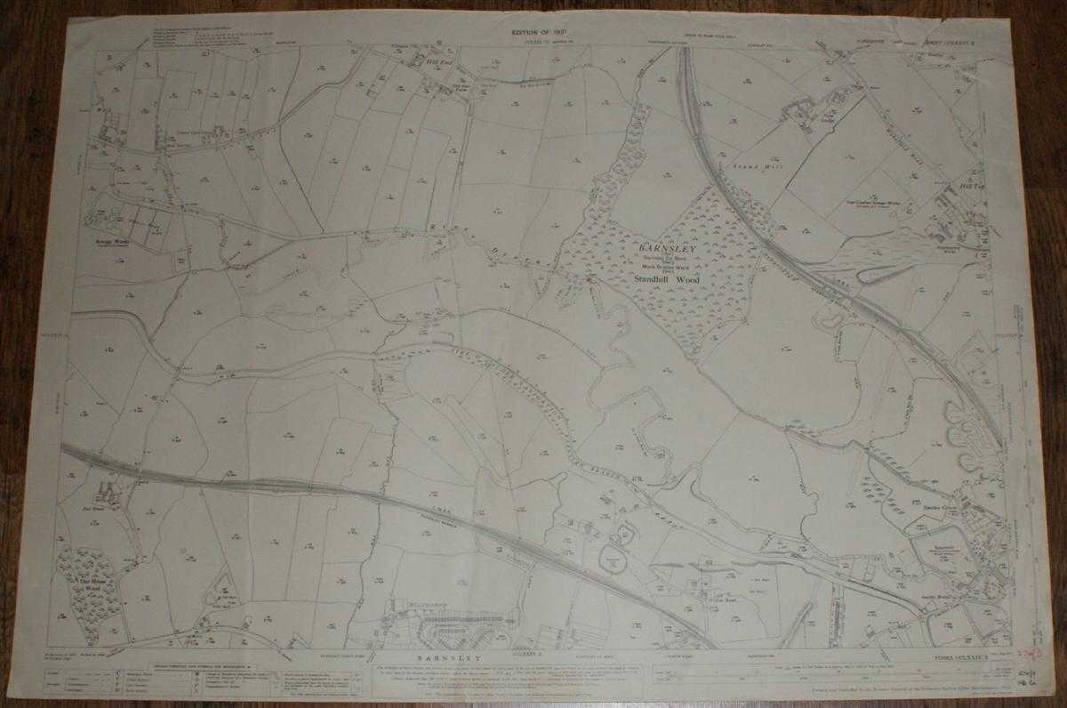
Title: 1:2,500 Ordnance Survey Map, Yorkshire (West Riding) Sheet CCLXXIV.3. Edition of 1931, Re-Surveyed 1891, Revised 1929, Re-Levelled 1930, Area North of Barnsley, Wilthorpe, Hill Top (part) & Hill End (part)
Description: Map Ordnance Survey, 1931. Revised Edition, Softcover. Good Condition/No Dust Jacket. Black and white map. Map is clean with slight wear and darkening to edges. Top right corner is torn and creased. Three vertical creases (all of which are slightly diagonal) but no formal central folds. Hand written figures in bottom right corner margin with faint stamp mark here also. Reverse is clean with three plain white reinforcing stickers. 1:2,500 Ordnance Survey Map, Yorkshire (West Riding) Sheet CCLXXIV.3. Edition of 1931, Re-Surveyed 1891, Revised 1929, Re-Levelled 1930, Area North of Barnsley, Wilthorpe, Hill Top (part) & Hill End (part) Includes: Barnsley (part), Wilthorpe, Smithies (part), Hill End (part), Hill Top (part), Swallow Hill (part), Willoe Bank, Day House L.M.S.R. Barnsley Branch (railway), L.N.E.R Stairfoot and Nostell (railway), Aire and Calder Navigation, River Dearne Carr Lane, Wakefeild Road, Smithies Lane Information included is buildings, property/field boundaries, acreage, parish and other boundaries, footpaths, tracks, roads, railways, watercourses, orchards and forestation, levels, earthworks, antiquities, etc Size: 73cm by 104cm. Item Type: Map. No dust jacket, as published. Single sheet map/chart which is suitable for framing and will be shipped rolled and in a cardboard tube.. Quantity Available: 1. Shipped Weight: under 1 kg. Pictures of this item not already displayed here available upon request. Inventory No: 45116121344. ISBN: 0750920963
Keywords: BZDB4 map, British history Maps; British History; England; 1930s; Yorkshire. Ordnance Survey 1:2,500 Ordnance Survey Map, Yorkshire (West Riding) Sheet CCLXXIV.3. Edition of 1931, Re-Surveyed 1891, Revised 1929, Re-Levelled 1930, Area North of Barnsley, W
See more books from our catalog: Maps
Title: 1:2,500 Ordnance Survey Map, Yorkshire (West Riding) Sheet CCLXXIV.3. Edition of 1931, Re-Surveyed 1891, Revised 1929, Re-Levelled 1930, Area North of Barnsley, Wilthorpe, Hill Top (part) & Hill End (part)
Description: Map Ordnance Survey, 1931. Revised Edition, Softcover. Good Condition/No Dust Jacket. Black and white map. Map is clean with slight wear and darkening to edges. Top right corner is torn and creased. Three vertical creases (all of which are slightly diagonal) but no formal central folds. Hand written figures in bottom right corner margin with faint stamp mark here also. Reverse is clean with three plain white reinforcing stickers. 1:2,500 Ordnance Survey Map, Yorkshire (West Riding) Sheet CCLXXIV.3. Edition of 1931, Re-Surveyed 1891, Revised 1929, Re-Levelled 1930, Area North of Barnsley, Wilthorpe, Hill Top (part) & Hill End (part) Includes: Barnsley (part), Wilthorpe, Smithies (part), Hill End (part), Hill Top (part), Swallow Hill (part), Willoe Bank, Day House L.M.S.R. Barnsley Branch (railway), L.N.E.R Stairfoot and Nostell (railway), Aire and Calder Navigation, River Dearne Carr Lane, Wakefeild Road, Smithies Lane Information included is buildings, property/field boundaries, acreage, parish and other boundaries, footpaths, tracks, roads, railways, watercourses, orchards and forestation, levels, earthworks, antiquities, etc Size: 73cm by 104cm. Item Type: Map. No dust jacket, as published. Single sheet map/chart which is suitable for framing and will be shipped rolled and in a cardboard tube.. Quantity Available: 1. Shipped Weight: under 1 kg. Pictures of this item not already displayed here available upon request. Inventory No: 45116121344. ISBN: 0750920963
Keywords: BZDB4 map, British history Maps; British History; England; 1930s; Yorkshire. Ordnance Survey 1:2,500 Ordnance Survey Map, Yorkshire (West Riding) Sheet CCLXXIV.3. Edition of 1931, Re-Surveyed 1891, Revised 1929, Re-Levelled 1930, Area North of Barnsley, W
Price: GBP 15.00 = appr. US$ 21.42 Seller: Bailgate Books Ltd
- Book number: 45116121344
- Book number: 45116121344
See more books from our catalog: Maps