Author: Ordnance Survey
Title: 1:2,500 Ordnance Survey Map, Yorkshire (West Riding) Sheet CCLXXIV.1. Edition of 1931, Re-Surveyed 1891, Revised 1929, Re-Levelled 1930, Cawthorne and Area to NE
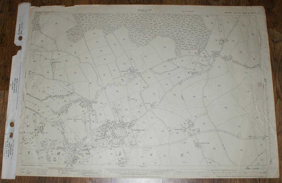
Description: Map Ordnance Survey, 1931. Revised Edition, Softcover. Good Condition/No Dust Jacket. Black and white map. Map is clean with light crumpling. Vertical centre fold with associated creasing and further vertical fold and creasing close to left edge. Right edge has filing strip adhered to it. Edges a little worn with small tears on top edge which do not extend into mapped area. Small stamp in bottom right corner margin. Reverse is lightly marked. 1:2,500 Ordnance Survey Map, Yorkshire (West Riding) Sheet CCLXXIV.1. Edition of 1931, Re-Surveyed 1891, Revised 1929, Re-Levelled 1930, Cawthorne and Area to NE Includes: Cawthorne, Barnby Hall, Cinder Hill, Cliffe Hill Bridge, Tivy Dale Bridge, Cawthorne Park (part) Cawthorne: Cemetery, All Saints' Church, Manor House, Spencer Arms Inn, Meth. Church, War Memorial, School, Museum Cawthorne Lane, (A635), Cawthorne Dike Information included is buildings, property/field boundaries, acreage, parish and other boundaries, footpaths, tracks, roads, railways, watercourses, orchards and forestation, levels, earthworks, antiquities, etc Size: 73cm by 104cm. Item Type: Map. No dust jacket, as published. Single sheet map/chart which is suitable for framing and will be shipped rolled and in a cardboard tube.. Quantity Available: 1. Shipped Weight: under 1 kg. Pictures of this item not already displayed here available upon request. Inventory No: 45116121330. ISBN: 0750920963
Keywords: BZDB4 map, British history Maps; British History; England; 1930s; Yorkshire. Ordnance Survey 1:2,500 Ordnance Survey Map, Yorkshire (West Riding) Sheet CCLXXIV.1. Edition of 1931, Re-Surveyed 1891, Revised 1929, Re-Levelled 1930, Cawthorne and Area to NE
See more books from our catalog: Maps
Title: 1:2,500 Ordnance Survey Map, Yorkshire (West Riding) Sheet CCLXXIV.1. Edition of 1931, Re-Surveyed 1891, Revised 1929, Re-Levelled 1930, Cawthorne and Area to NE
Description: Map Ordnance Survey, 1931. Revised Edition, Softcover. Good Condition/No Dust Jacket. Black and white map. Map is clean with light crumpling. Vertical centre fold with associated creasing and further vertical fold and creasing close to left edge. Right edge has filing strip adhered to it. Edges a little worn with small tears on top edge which do not extend into mapped area. Small stamp in bottom right corner margin. Reverse is lightly marked. 1:2,500 Ordnance Survey Map, Yorkshire (West Riding) Sheet CCLXXIV.1. Edition of 1931, Re-Surveyed 1891, Revised 1929, Re-Levelled 1930, Cawthorne and Area to NE Includes: Cawthorne, Barnby Hall, Cinder Hill, Cliffe Hill Bridge, Tivy Dale Bridge, Cawthorne Park (part) Cawthorne: Cemetery, All Saints' Church, Manor House, Spencer Arms Inn, Meth. Church, War Memorial, School, Museum Cawthorne Lane, (A635), Cawthorne Dike Information included is buildings, property/field boundaries, acreage, parish and other boundaries, footpaths, tracks, roads, railways, watercourses, orchards and forestation, levels, earthworks, antiquities, etc Size: 73cm by 104cm. Item Type: Map. No dust jacket, as published. Single sheet map/chart which is suitable for framing and will be shipped rolled and in a cardboard tube.. Quantity Available: 1. Shipped Weight: under 1 kg. Pictures of this item not already displayed here available upon request. Inventory No: 45116121330. ISBN: 0750920963
Keywords: BZDB4 map, British history Maps; British History; England; 1930s; Yorkshire. Ordnance Survey 1:2,500 Ordnance Survey Map, Yorkshire (West Riding) Sheet CCLXXIV.1. Edition of 1931, Re-Surveyed 1891, Revised 1929, Re-Levelled 1930, Cawthorne and Area to NE
Price: GBP 15.00 = appr. US$ 21.42 Seller: Bailgate Books Ltd
- Book number: 45116121330
- Book number: 45116121330
See more books from our catalog: Maps