Author: Pigot and Co
Title: 1839 Map of the County of Herefordshire - taken from Pigot and Co's British Atlas Comprising the Counties of England (upon which are laid down all railways completed and in progress)
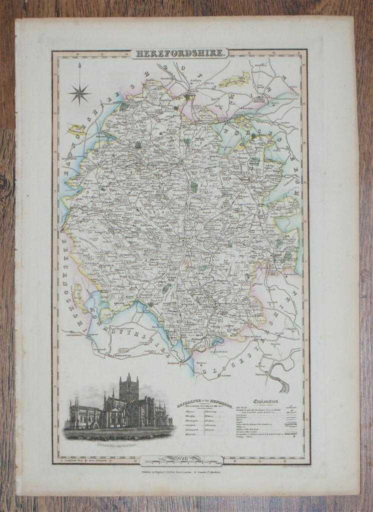
Description: Map Pigot & Co, London and Manchester, 1839. Edition Unstated, Softcover. Very Good/No Dust Jacket. Dated from reference to British Library catalogue and title-page of atlas. This is the coloured map titled "Herefordshire" and sheet entitled "Herefordshire". The map, a hand-coloured (prior to initial binding) steel engraving contains a vignette of Hereford Cathedral. The inner side of the Herefordshire county boundary is coloured yellow, inner boundaries of adjacent counties of Worcestershire, Radnorshire, Monmouthshire, Shropshire, Glocestershire and Brecknockshire are coloured pale green, blue or pink. Wooded areas and rough ground are indicated. Country estates are coloured dark green and include Hampton and Brampton Parks. The map shows cities, market towns, villages and hamlets, the distance between the towns and cities and London is shown, also shown are the numbers of members returned for each borough and polling places. Towns shown include: Bromyard, Hereford, Kington, Ledbury, Leominster, Ross and Weobley, distances between these towns are given in a table on the accompanying sheet. Mail roads, Turnpike roads, cross roads, lanes and other minor routes are shown with distances marked between Market Towns on the Turnpike Roads. Railways, rivers and canals are shown, including the River Wye and the River Arrow. Mail and Turnpike roads and towns and principal villages in the neighbouring parts of adjacent counties are also shown. The boundaries of the "Hundreds" are shown and the names of each Hundred are identified in the key. The border includes longitude and latitude references and the scale is given in the bottom border which for this map is 1.5 inches to 10 miles. The map is a little darkened and has some very slight marks but is free from tears. The edges are very slightly worn. The accompanying printed sheet has a slightly rough previously bound edge and a faint crease across the bottom right corner but is otherwise good. Item Type: Map. Disbound. No dust jacket, as published. Single sheet map/chart. Quantity Available: 1. Shipped Weight: under 1 kg. Pictures of this item not already displayed here available upon request. Inventory No: 45017044024. ISBN: 0709133766
Keywords: BZDB4 Maps; British History; England; 19th century; Herefordshire, Shropshire, Staffordshire. Pigot and Co 1839 Map of the County of Herefordshire - taken from Pigot and Co's British Atlas Comprising the Counties of England (upon which are laid down all r
See more books from our catalog: Maps
Title: 1839 Map of the County of Herefordshire - taken from Pigot and Co's British Atlas Comprising the Counties of England (upon which are laid down all railways completed and in progress)
Description: Map Pigot & Co, London and Manchester, 1839. Edition Unstated, Softcover. Very Good/No Dust Jacket. Dated from reference to British Library catalogue and title-page of atlas. This is the coloured map titled "Herefordshire" and sheet entitled "Herefordshire". The map, a hand-coloured (prior to initial binding) steel engraving contains a vignette of Hereford Cathedral. The inner side of the Herefordshire county boundary is coloured yellow, inner boundaries of adjacent counties of Worcestershire, Radnorshire, Monmouthshire, Shropshire, Glocestershire and Brecknockshire are coloured pale green, blue or pink. Wooded areas and rough ground are indicated. Country estates are coloured dark green and include Hampton and Brampton Parks. The map shows cities, market towns, villages and hamlets, the distance between the towns and cities and London is shown, also shown are the numbers of members returned for each borough and polling places. Towns shown include: Bromyard, Hereford, Kington, Ledbury, Leominster, Ross and Weobley, distances between these towns are given in a table on the accompanying sheet. Mail roads, Turnpike roads, cross roads, lanes and other minor routes are shown with distances marked between Market Towns on the Turnpike Roads. Railways, rivers and canals are shown, including the River Wye and the River Arrow. Mail and Turnpike roads and towns and principal villages in the neighbouring parts of adjacent counties are also shown. The boundaries of the "Hundreds" are shown and the names of each Hundred are identified in the key. The border includes longitude and latitude references and the scale is given in the bottom border which for this map is 1.5 inches to 10 miles. The map is a little darkened and has some very slight marks but is free from tears. The edges are very slightly worn. The accompanying printed sheet has a slightly rough previously bound edge and a faint crease across the bottom right corner but is otherwise good. Item Type: Map. Disbound. No dust jacket, as published. Single sheet map/chart. Quantity Available: 1. Shipped Weight: under 1 kg. Pictures of this item not already displayed here available upon request. Inventory No: 45017044024. ISBN: 0709133766
Keywords: BZDB4 Maps; British History; England; 19th century; Herefordshire, Shropshire, Staffordshire. Pigot and Co 1839 Map of the County of Herefordshire - taken from Pigot and Co's British Atlas Comprising the Counties of England (upon which are laid down all r
Price: GBP 28.00 = appr. US$ 39.98 Seller: Bailgate Books Ltd
- Book number: 45017044024
- Book number: 45017044024
See more books from our catalog: Maps