Author: Various / Unstated
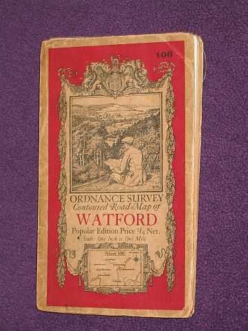
Title: Ordnance Survey Contoured Road Map of Watford - Popular Edition No 106 - 1 inch to 1 Mile
Description: Map Director General, Ordnance Survey, Southampton, 1930. Reprint, Card Covers, Illustrated by: Martin, Ellis. Very Good/N/A.. cloth; Ellis Martin illust. to front; last revision (3rd.) in 1913-14, printed 1920 with minor corrections 1929, railways inserted to 1927, fourth reprint 1930; a few small holes at fold crossings & light edge-wear to covers Item Type: Map. Illustrator: Martin, Ellis. Quantity Available: 1. Category: Geography & Maps; Great Britain; Britain/UK; Travel & Places. Inventory No: MAP00005.
Keywords: BZDB227 Maps/Ordnance Survey/Great Britain Geography & Maps; Great Britain; Britain/UK; Travel & Places. Martin, Ellis Unbranded Various / Unstated Ordnance Survey Contoured Road Map of Watford - Popular Edition No 106 - 1 inch to 1 Mile Great Britain
See more books from our catalog: Geography & Maps
Title: Ordnance Survey Contoured Road Map of Watford - Popular Edition No 106 - 1 inch to 1 Mile
Description: Map Director General, Ordnance Survey, Southampton, 1930. Reprint, Card Covers, Illustrated by: Martin, Ellis. Very Good/N/A.. cloth; Ellis Martin illust. to front; last revision (3rd.) in 1913-14, printed 1920 with minor corrections 1929, railways inserted to 1927, fourth reprint 1930; a few small holes at fold crossings & light edge-wear to covers Item Type: Map. Illustrator: Martin, Ellis. Quantity Available: 1. Category: Geography & Maps; Great Britain; Britain/UK; Travel & Places. Inventory No: MAP00005.
Keywords: BZDB227 Maps/Ordnance Survey/Great Britain Geography & Maps; Great Britain; Britain/UK; Travel & Places. Martin, Ellis Unbranded Various / Unstated Ordnance Survey Contoured Road Map of Watford - Popular Edition No 106 - 1 inch to 1 Mile Great Britain
Price: GBP 12.00 = appr. US$ 17.14 Seller: Bookbarrow
- Book number: MAP00005
- Book number: MAP00005
See more books from our catalog: Geography & Maps