Author: LELEWEL, JOACHIM.
Title: Geographie du Moyen Age. Accompagnee d'Atlas et de Cartes dans chaque Volume Five Volumes of text boumd in two octavo volumes, together with atlas.
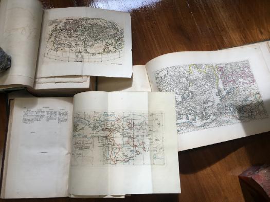
Description: Text Volumes Vol. I. pp 16, [iv], cxxxvi, 186; Vol. II. pp. 243; Vol, III & IV pp 220, 112; Vol V. viii, 308; Text volumes have 18 engraved plates (mostly folding, 3 with outline colouring), first four volumes bound in green cloth with black leather spine, fifth volume bound in brown cloth; Atlas Volume pp. xiv, [vi], 49, 30; illustrated with 50 plates, 49 engraved and one lithograph vignette laid on to title page, table or indicator of longitudes and latitudes of Arabic geographers, bound in half morocco with patterned papered boards, raised bands, title lettered in gilt on spine, good sound and clean copies. Brussels;V & J Pilliet, 1852-1857 (text) and Breslau, S. Schletter, 1854 (atlas). Lelewel's study of medieval geography from Greek, Latin and Arab sources. Lelewel was considered by many to be a pioneer writer on cartography.
Keywords: cartography atlas maps history
Title: Geographie du Moyen Age. Accompagnee d'Atlas et de Cartes dans chaque Volume Five Volumes of text boumd in two octavo volumes, together with atlas.
Description: Text Volumes Vol. I. pp 16, [iv], cxxxvi, 186; Vol. II. pp. 243; Vol, III & IV pp 220, 112; Vol V. viii, 308; Text volumes have 18 engraved plates (mostly folding, 3 with outline colouring), first four volumes bound in green cloth with black leather spine, fifth volume bound in brown cloth; Atlas Volume pp. xiv, [vi], 49, 30; illustrated with 50 plates, 49 engraved and one lithograph vignette laid on to title page, table or indicator of longitudes and latitudes of Arabic geographers, bound in half morocco with patterned papered boards, raised bands, title lettered in gilt on spine, good sound and clean copies. Brussels;V & J Pilliet, 1852-1857 (text) and Breslau, S. Schletter, 1854 (atlas). Lelewel's study of medieval geography from Greek, Latin and Arab sources. Lelewel was considered by many to be a pioneer writer on cartography.
Keywords: cartography atlas maps history
Price: AUD 950.00 = appr. US$ 657.28 Seller: Time Booksellers
- Book number: 116372
- Book number: 116372