Author: ,
Title: Map of LEICESTERSHIRE & RUTLANDSHIRE.
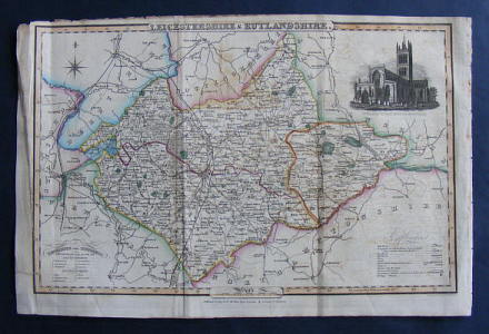
Description: Pigot & Co., London & Manchester, 1841, printed area 13.75 inches (34.5 cm) wide by 8.75 inches (22.5 cm) with reasonable margins, steel engraved hand coloured map on a single sheet extracted from Pigot's National and Commercial Directory covering the County with a vignette of St. Mary's Church, Melton Mowbray, indicating the Hundreds of both Counties and showing the Mail Roads, Turnpikes, Railroads, Rivers, Canals, Towns and Villages, rubbed at extrems., with several edge nicks repaired to reverse, creases where previously folded, a little dusty, some offsetting,
Keywords: pigot map leicestershire rutland melton mowbray uppingham oakham loughborough charnwood leicester market harborough bosworth lutterworth hinckley ashby mount sorrel ashby de la zouch woulds belvoir cabinet
See more books from our catalog: Topography and Local History - Britain
Title: Map of LEICESTERSHIRE & RUTLANDSHIRE.
Description: Pigot & Co., London & Manchester, 1841, printed area 13.75 inches (34.5 cm) wide by 8.75 inches (22.5 cm) with reasonable margins, steel engraved hand coloured map on a single sheet extracted from Pigot's National and Commercial Directory covering the County with a vignette of St. Mary's Church, Melton Mowbray, indicating the Hundreds of both Counties and showing the Mail Roads, Turnpikes, Railroads, Rivers, Canals, Towns and Villages, rubbed at extrems., with several edge nicks repaired to reverse, creases where previously folded, a little dusty, some offsetting,
Keywords: pigot map leicestershire rutland melton mowbray uppingham oakham loughborough charnwood leicester market harborough bosworth lutterworth hinckley ashby mount sorrel ashby de la zouch woulds belvoir cabinet
Price: GBP 25.00 = appr. US$ 35.70 Seller: A Book for all Reasons
- Book number: 37986
- Book number: 37986
See more books from our catalog: Topography and Local History - Britain