Author: L'ISLE, Guillaume de.
Title: Atlas nouveau, contenant toutes les parties du monde, ou sont exactement remarquées les empires, monarchies, royaumes, etats, republiques &c.Including: SANSON, Guillaume. Introduction à la Geographie où sont la geographie astronomique qui explique la correspondance du globe terrestre avec la sphere.Amsterdam, Johannes Covens and Cornelis Mortier, 1730. Folio. With a large allegorical frontispiece and 56 large copper-engraved maps (most 54 x 65 cm and a few larger, folding ones). Previous owners have added one large copper-engraved map of Normandie by Jean Baptiste Nolin from 1742, and 2 smaller etchings by Israel Silvestre with views of du Havre and Chateau Jametz. The original artwork of these views is from the 1670s, but these prints are from a later date. Contemporary blind-tooled vellum, green closing ties.
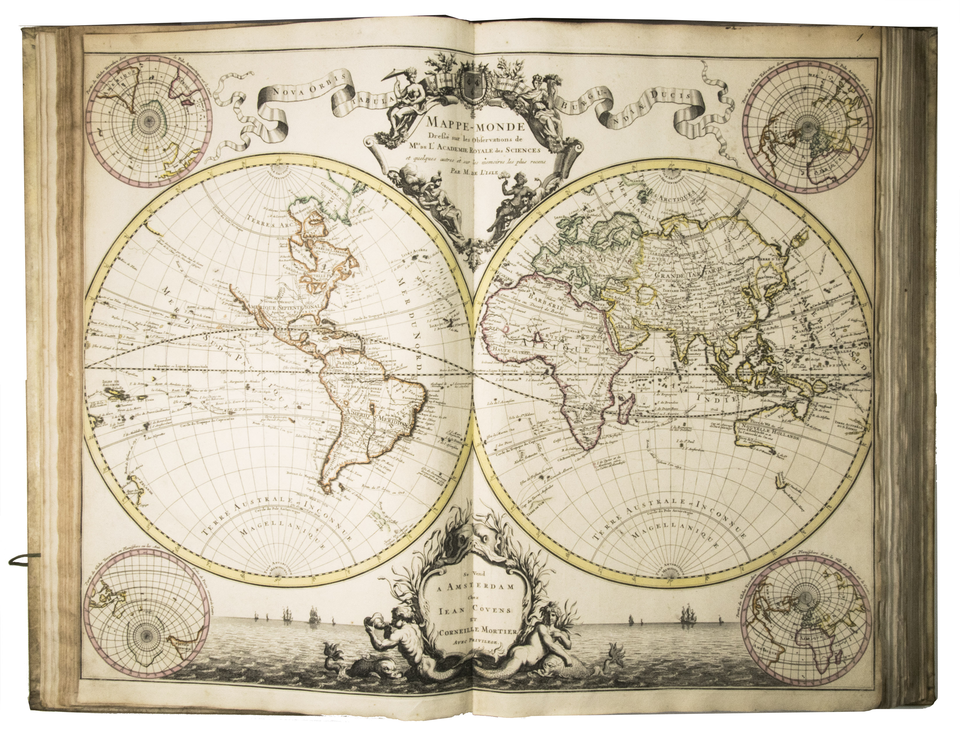
Description: [1 blank], [6], 32 pp.A rare, beautiful and accurate world atlas with 56 large maps, all but one coloured in outline by a contemporary hand. This work was published many times, but this is a very early edition. Many of the maps include fine pictorial decorations, coats of arms or decorative cartouches. The atlas is a re-issue of the atlas by Guillaume de l'Isle (1675 - 1726), the great Paris cartographer. Most maps are by his hand, though they were re-engraved for Covens and Mortier.The Dutch had pioneered the field of cartography in the late 16th- and the 17th-century, but in 1666 Louis XIV established the Paris Académie des Sciences, in part to advance French cartography for military, administrative and economic reasons. France began to take over the Netherlands leading role toward the end of the century but reached its peak with the work of De lIsle in the early 18th-century. He gained much renown internationally for the accuracy and beauty of his maps. The Netherlands nevertheless remained the most important centre of the booktrade, and Pieter Mortier, who had conducted an extensive trade in the French book and map market, began publishing his own versions of De lIsles maps in 1708. His successors Johannes Covens I & Cornelis Mortier greatly expanded the range, publishing a De lIsle world atlas of 50 maps in 1730, along with a Dutch translation of the geographical compendium, Introduction à la geographie, by Nicolas Sanson. They continued to add further maps by leading cartographers after De lIsles death. In 1741 they advertised a major new version of their atlas and it continued to grow, the later advertisements also noting that those who had already purchased the De lIsle atlas could buy the newer maps to supplement it. Since Covens and Mortier added maps continuously and encouraged customers to update the atlases they had purchased, and since individual customers might choose to add or omit some maps to suit their own wishes, one rarely finds two copies with an identical make-up.This atlas is an early edition. It is very similar to C&M 4, the copy Koeman found in the University of Amsterdam. However, C&M 4 has two tables with informaton about the French departements that were not bound into this copy. In contrast, this copy has maps of Congo and Martinique that cannot be found in C&M 4.With an ex-libris ("Mr. W. C. Baert de Waarde") mounted on the front pastedown. Scratches and brown stains on the binding. Small tears in the margins of some of the maps. Minor foxing in the first part of the work. Otherwise in very good condition.l Marco van Egmond, Covens & Mortier, pp. 139-142; Koeman 2, pp. 45- 53; STCN 283581492 (5 copies); Van der Krogt, Advertenties 848, 882 & 893; Worldcat 43051497, 71429255, 914264492 (9 copies).
Keywords: [80CBADC1D9E8] CARTOGRAPHY & EXPLORATION|[80CBADC1D9E8] CARTOGRAPHY & EXPLORATION -> [D1FD79398985] Atlases, Charts, Maps & Globes|
Title: Atlas nouveau, contenant toutes les parties du monde, ou sont exactement remarquées les empires, monarchies, royaumes, etats, republiques &c.Including: SANSON, Guillaume. Introduction à la Geographie où sont la geographie astronomique qui explique la correspondance du globe terrestre avec la sphere.Amsterdam, Johannes Covens and Cornelis Mortier, 1730. Folio. With a large allegorical frontispiece and 56 large copper-engraved maps (most 54 x 65 cm and a few larger, folding ones). Previous owners have added one large copper-engraved map of Normandie by Jean Baptiste Nolin from 1742, and 2 smaller etchings by Israel Silvestre with views of du Havre and Chateau Jametz. The original artwork of these views is from the 1670s, but these prints are from a later date. Contemporary blind-tooled vellum, green closing ties.
Description: [1 blank], [6], 32 pp.A rare, beautiful and accurate world atlas with 56 large maps, all but one coloured in outline by a contemporary hand. This work was published many times, but this is a very early edition. Many of the maps include fine pictorial decorations, coats of arms or decorative cartouches. The atlas is a re-issue of the atlas by Guillaume de l'Isle (1675 - 1726), the great Paris cartographer. Most maps are by his hand, though they were re-engraved for Covens and Mortier.The Dutch had pioneered the field of cartography in the late 16th- and the 17th-century, but in 1666 Louis XIV established the Paris Académie des Sciences, in part to advance French cartography for military, administrative and economic reasons. France began to take over the Netherlands leading role toward the end of the century but reached its peak with the work of De lIsle in the early 18th-century. He gained much renown internationally for the accuracy and beauty of his maps. The Netherlands nevertheless remained the most important centre of the booktrade, and Pieter Mortier, who had conducted an extensive trade in the French book and map market, began publishing his own versions of De lIsles maps in 1708. His successors Johannes Covens I & Cornelis Mortier greatly expanded the range, publishing a De lIsle world atlas of 50 maps in 1730, along with a Dutch translation of the geographical compendium, Introduction à la geographie, by Nicolas Sanson. They continued to add further maps by leading cartographers after De lIsles death. In 1741 they advertised a major new version of their atlas and it continued to grow, the later advertisements also noting that those who had already purchased the De lIsle atlas could buy the newer maps to supplement it. Since Covens and Mortier added maps continuously and encouraged customers to update the atlases they had purchased, and since individual customers might choose to add or omit some maps to suit their own wishes, one rarely finds two copies with an identical make-up.This atlas is an early edition. It is very similar to C&M 4, the copy Koeman found in the University of Amsterdam. However, C&M 4 has two tables with informaton about the French departements that were not bound into this copy. In contrast, this copy has maps of Congo and Martinique that cannot be found in C&M 4.With an ex-libris ("Mr. W. C. Baert de Waarde") mounted on the front pastedown. Scratches and brown stains on the binding. Small tears in the margins of some of the maps. Minor foxing in the first part of the work. Otherwise in very good condition.l Marco van Egmond, Covens & Mortier, pp. 139-142; Koeman 2, pp. 45- 53; STCN 283581492 (5 copies); Van der Krogt, Advertenties 848, 882 & 893; Worldcat 43051497, 71429255, 914264492 (9 copies).
Keywords: [80CBADC1D9E8] CARTOGRAPHY & EXPLORATION|[80CBADC1D9E8] CARTOGRAPHY & EXPLORATION -> [D1FD79398985] Atlases, Charts, Maps & Globes|
Price: EUR 45000.00 = appr. US$ 48908.11 Seller: A. Asher & Co. B.V.
- Book number: ABC_47813
- Book number: ABC_47813