Author: DARTON, WILLIAM, JR.
Title: Map of Spain & Portugal (Framed and Matted)
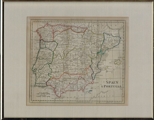
Description: London: Walkers Geography, 1802. First Printing. Non-Book. Map by William Darton, Jr. from Atlas to Walker's Geography. London: Vernor and Hood, etc, 1802. Engraved. Original outline color. William Darton, Sr. began his map-making business in 1787 in London. His cartographic publishing house would last, in various manifestations, until the 1860s. William Darton, Jr. joined his father late in the eighteenth century and this is a map engraved by him for Walker's Geography. While not large (c. 8.5" x 7.5"), the maps contain an impressive amount of detail, which is quite carefully presented. The information used was the best available in London at the beginning of the nineteenth century, meaning the best in the world, so this map is not only attractive, but provides an excellent cartographic picture of Spain and Portugal at the beginning of the 19th century.. NEAR FINE, framed and matted. Engraving. 10" x 9". 1 pp. Near Fine with no dust jacket .
Keywords: Maps Spain Portugal 19th Century Atlas Art, Antiques & Photography Science, Medicine & Technology
See more books from our catalog: Geography
Title: Map of Spain & Portugal (Framed and Matted)
Description: London: Walkers Geography, 1802. First Printing. Non-Book. Map by William Darton, Jr. from Atlas to Walker's Geography. London: Vernor and Hood, etc, 1802. Engraved. Original outline color. William Darton, Sr. began his map-making business in 1787 in London. His cartographic publishing house would last, in various manifestations, until the 1860s. William Darton, Jr. joined his father late in the eighteenth century and this is a map engraved by him for Walker's Geography. While not large (c. 8.5" x 7.5"), the maps contain an impressive amount of detail, which is quite carefully presented. The information used was the best available in London at the beginning of the nineteenth century, meaning the best in the world, so this map is not only attractive, but provides an excellent cartographic picture of Spain and Portugal at the beginning of the 19th century.. NEAR FINE, framed and matted. Engraving. 10" x 9". 1 pp. Near Fine with no dust jacket .
Keywords: Maps Spain Portugal 19th Century Atlas Art, Antiques & Photography Science, Medicine & Technology
Price: US$ 200.00 Seller: Round Table Books, LLC
- Book number: 22279
- Book number: 22279
See more books from our catalog: Geography