Author: Southern Pacific Lines (San Francisco, Calif.)
Title: Industry Map and Switching Limits Map of San Francisco and Vicinity, San Francisco County, Ca
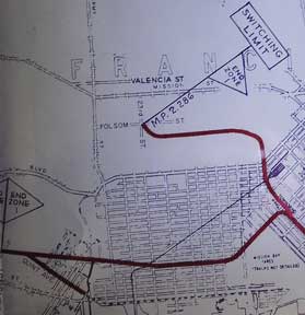
Description: San Francisco, Calif.: Southern Pacific Company, 1949, rev. 1958, switching limit map 1961. Blueline print, 27 inches x 96 inches. From Millbrae to Yerba Buena Island, Hunter's Point to Daly City. With index to industry, approx. 1000 entries, listed both Alphabetically and by numerical location on map. Scale approx 1 inch = 1200 feet. With two attached blueline print switching zones map,14 inches x 32 inches, four colors indicating zones, one dated 1961, one undated. From San Bruno to Presidio. Four pages of Switching Charges, effective 1960, attached. .
Keywords: San Francisco, Railroad, Environment, Industry
See more books from our catalog: Ephemera
Title: Industry Map and Switching Limits Map of San Francisco and Vicinity, San Francisco County, Ca
Description: San Francisco, Calif.: Southern Pacific Company, 1949, rev. 1958, switching limit map 1961. Blueline print, 27 inches x 96 inches. From Millbrae to Yerba Buena Island, Hunter's Point to Daly City. With index to industry, approx. 1000 entries, listed both Alphabetically and by numerical location on map. Scale approx 1 inch = 1200 feet. With two attached blueline print switching zones map,14 inches x 32 inches, four colors indicating zones, one dated 1961, one undated. From San Bruno to Presidio. Four pages of Switching Charges, effective 1960, attached. .
Keywords: San Francisco, Railroad, Environment, Industry
Price: US$ 750.00 Seller: Wittenborn Art Books
- Book number: 58-0497
- Book number: 58-0497
See more books from our catalog: Ephemera