Author: Southern Pacific Lines (San Francisco, Calif.)
Title: Right of Way and Track Map - Palo Alto, Mayfield to Vasona Junction, Santa Clara County, California
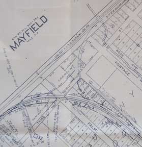
Description: San Francisco, Calif.: Southern Pacific Company, 1938. Map. Blueline print. 24 x 56 inches. With red and orange pencilling. Map of Mayfield with Schedule of Property Acquisition (Date, Original Grantor/Grantee, Instrument of Transfer, and Remarks of Sale) for approximately 9 transfers, 1809-1938. Scale: 1 inch = 200 feet. Includes index map showing sheets of Val. Sec. Scale: 1 inch = 1 mile. .
Keywords: Mayfield, Palo Alto, Stanford, Santa Clara, Railroad, Environment, Industry
See more books from our catalog: Ephemera
Title: Right of Way and Track Map - Palo Alto, Mayfield to Vasona Junction, Santa Clara County, California
Description: San Francisco, Calif.: Southern Pacific Company, 1938. Map. Blueline print. 24 x 56 inches. With red and orange pencilling. Map of Mayfield with Schedule of Property Acquisition (Date, Original Grantor/Grantee, Instrument of Transfer, and Remarks of Sale) for approximately 9 transfers, 1809-1938. Scale: 1 inch = 200 feet. Includes index map showing sheets of Val. Sec. Scale: 1 inch = 1 mile. .
Keywords: Mayfield, Palo Alto, Stanford, Santa Clara, Railroad, Environment, Industry
Price: US$ 350.00 Seller: Wittenborn Art Books
- Book number: 56-0221
- Book number: 56-0221
See more books from our catalog: Ephemera